NevCAN:
The Nevada Climate-ecohydrological Assessment Network
Nevada Climate Change: Exploring the past, present and future of the Great Basin and Mojave Deserts; science, education, policy and outreach
The Universities of Nevada (Reno and Las Vegas) and the Desert Research Institute have collaborated with land owner agencies in Nevada to establish two elevational transects of monitoring stations collectively named the Nevada Climate-ecohydrological Assessment Network (NevCAN). These basin-to-mountain top transects are located in the Sheep Range (located approx 35 km NNW of Las Vegas) and in the Snake Range (east central NV along the UT border; approx 335 km NNE of Las Vegas). The primary purpose of NevCAN is to collect data for long-term assessment of climate variability and change and its impact on ecological and hydrological processes and function.
The Snake Range transect has eight monitoring stations beginning at an elevation of 1757 m on the west side of the range, peaking at 3358 m at the western subalpine site and ending at 1566 m on the eastern side of the range. The Snake Range transect encompasses several collaborating land holder agencies including: the Long Now Foundation, Bureau of Land Management, Great Basin National Park and the Nevada Land Trust.
The Sheep Range transect has four monitoring stations beginning at an elevation of 894 m and ending at 2274 m. All of the monitoring stations are located on land managed by the U.S. Fish and Wildlife Service. Some stations are co-located with Natural Resource Conservation Service (NRCS) Soil Climate Analysis Network (SCAN) sites.
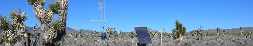
NevCAN Instrumentation
A consistent set of sensors are installed at each station to monitor precipitation, air temperature, wind speed and direction, incoming solar radiation, net radiation, relative humidity, barometric pressure, soil moisture and temperature at several depths. A webcam is mounted on each tower to provide real time assessment of site conditions as well as archival photographs to help assess plant phenology, snow depth and snow melt timing.
Networking capabilities provide real time transmission of data and webcam images to the Nevada Climate Change Data Portal where any interested person may download data free-of-charge. A subset of the data also are avaialable from the Western Regional Climate Center. One of the primary NevCAN goals is to make climate change science and data accessible to all and thus enhance understanding of climate variability and its impacts.
